This faucet at the Assiniboine & Sioux Rural Water Supply System's treatment plant runs 24/7 to test for contaminants in the drinking water. Much of Fort Peck's drinking water was contaminated by oil pollution in the 20th century, necessitating construction of the ASRWSS, which some say Keystone XL now threatens. Photo by Erika Peterman for Montana Free Press
'We're just outnumbered and out-moneyed': Fort Peck Tribes fight Keystone XL
Thursday, August 30, 2018
Oil and water: The fight to save clean water on the Fort Peck Indian Reservation
By Hunter Pauli
Montana Free Press montanafreepress.org
POPLAR — Lance Four Star drives west at 70 miles per hour using his knees to work the steering wheel as he watches Montana Sen. Jon Tester’s Indian Country Facebook town hall on his wife’s smartphone, the video starting and stopping as the cellular signal goes in and out on the 40-mile drive from the middle of the Fort Peck Indian Reservation to its border.
There aren’t many jobs on this 2-million-acre reservation in Montana’s northeast corner, and Four Star is brushing up on Tester’s policy positions before an interview for a job on the Democrat’s re-election campaign, which is in its last hundred days. As a U.S. Army veteran, Four Star supports Tester’s work reforming the Department of Veterans Affairs, but disagrees with Tester on one major issue:
“‘Will you stop the pipelines from entering Montana?’” Four Star reads aloud from the comment section of the Facebook stream.
Chairman of the Fort Peck Assiniboine Council Lance Four Star watches an Indian Country town hall with U.S. Sen. Jon Tester while driving through Wolf Point on the Fort Peck Indian Reservation. Four Star is applying for a job on the Tester campaign and supports the senator’s policies — except his approval of the Keystone XL oil pipeline.
Photo by Erika Peterman for Montana Free Press
The phone loses signal again before Four Star can see if the question is answered, but the senator’s position is no mystery. Just like every other top politician in the state, Democrat and Republican, state and federal, Tester supports construction of the Keystone XL tar sands pipeline, which is slated to cross the Missouri River a quarter mile upriver of Fort Peck’s southwestern border when construction begins next year.
“We’re just outnumbered and out-moneyed,” Four Star says, guiding his Ford F-150 along U.S. Route 2 as it parallels the bulbous petroleum train cars regularly traversing the BNSF rail line. The tanker convoys arrive empty at the Bakken oil patch just to the east and the Alberta tar sands far to the north, and leave full for refineries and export terminals.
Four Star fears that if any of the trains rolling through the tribal seat of Poplar or the reservation’s largest town of Wolf Point ever derailed, it could blow up the entire town — a point pipeline supporters also make. But to Four Star, the Keystone XL pipeline is no less threatening to his community than crude oil traveling through by train.
Four Star is the chairman of the Fort Peck Assiniboine Council, which is separate from — and predates — the Fort Peck Assiniboine & Sioux Tribal Executive Board that is recognized by the Bureau of Indian Affairs as the reservation’s elected governing body. Fort Peck is a two-tribe reservation, and the Sioux also have a non-governing council.
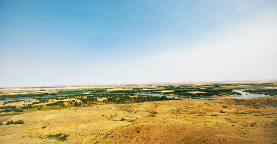
Canadian pipeline company TransCanada plans for Keystone XL to cross beneath the riverbed of the Missouri River about a quarter mile upstream of the confluence with the Milk River, the reservation’s southwestern border. Two miles upriver of the proposed crossing site is the mile-long spillway of the Fort Peck Dam. The spillway itself functions as a safety valve to rapidly release water from the fifth largest reservoir in America when it gets dangerously high.
The proposed route of the Keystone XL pipeline in northeastern Montana. Sources: USGS, U.S. Census Bureau, Montana DEQ. Graphic by Eric Dietrich for Montana Free Press
Seventy miles downriver, on the reservation, is the intake plant for the Assiniboine & Sioux Rural Water Supply System, a $300 million congressionally mandated drinking water treatment and supply network built after oil drilling turned much of the tribe’s aquifer north of Poplar saline and carcinogenic. Two agricultural water intakes are farther upriver, between the intake and the proposed pipeline. The big concern for local pipeline opponents like Four Star is a doomsday scenario in which heavy snowpack and spring rains fill the reservoir to its capacity, which would mandate a huge release of water from the dam to prevent it from failing. That torrent of water flowing out of the spillway would scour the riverbed downstream, and that scouring could damage or rupture the pipeline, releasing diluted tar sands bitumen into the river.
In 2010, a pipeline owned by Canadian pipeline company Enbridge, Inc. spilled more than 1 million gallons of tar sands crude into the Kalamazoo River in Kalamazoo, Mich. A National Transportation Safety Board investigation of that incident found that diluted bitumen breaks down into its constituent chemicals, including benzene, a known carcinogen, when spilled into a river.
If a spill like that were to happen in the Missouri River, those toxic chemicals could be sucked into the Fork Peck water network’s intake, which could wreck the system, require an emergency shutoff, or poison the tribes’ drinking water a second time.
In a 2013 letter to the State Department reviewing the draft environmental impact statement for Keystone XL, the EPA Office of Enforcement and Compliance Assurance referenced the dangers exposed by the Kalamazoo diluted bitumen spill, particularly benzene, and recommended that the EIS reflect the additional risks present in diluted bitumen spills.
The fear that such a spill could result from a massive release of water from the reservoir isn’t unfounded. Such a release happened in 2011 during record-high runoff and caused an more than $200 million in damage to the spillway.
TransCanada has repeatedly said the proposed 36-inch pipeline will be state-of-the-art and will never break, but the company hasn’t convinced the plaintiffs suing the U.S. departments of State and Interior in Great Falls’ Missouri River Courthouse more than 300 miles upstream.
Montana Free Press: Keystone XL could threaten tribal water system. Video by Colin Ruggiero
Four Star speaks of when the pipeline breaks, not if.
“Unless you take [the pipeline] out, at some point … it’s going to erode. It will leak,” he says.
It’s easy to think in a geological time scale in the traditional Assiniboine wintering grounds, where the floodplains meet the highland valleys where tyrannosauruses once roamed, now submerged beneath the reservoir.
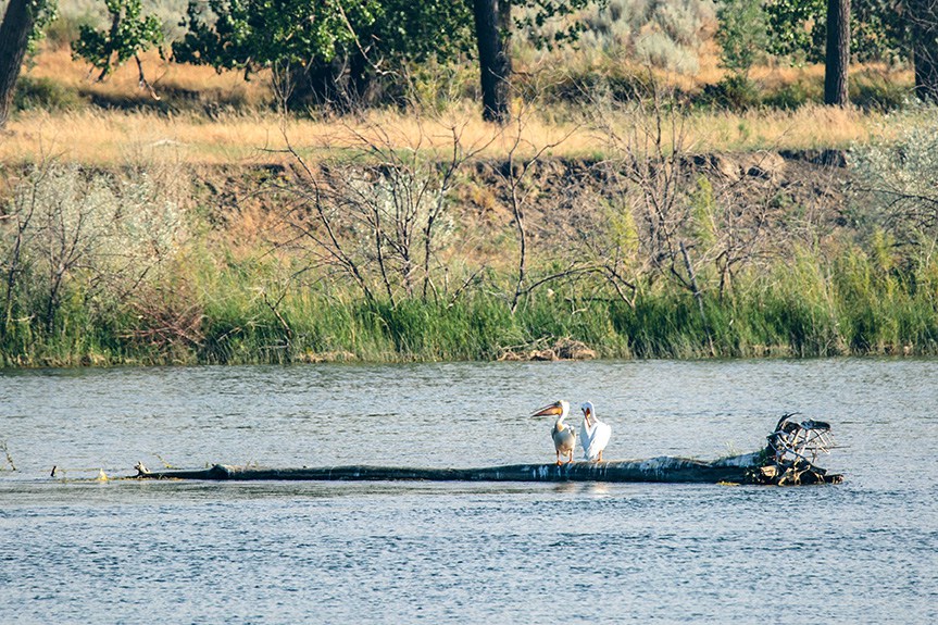
This section of the Missouri River runs clear and clean, visibly teeming with waterfowl and fish, including, not so visibly, some of the last remaining pallid sturgeon, living fossils that survived the meteor that wiped out the dinosaurs only to face the threat of extinction from the dams destroying their habitat.
The remote Montana portion of the Keystone XL pipeline hasn’t attracted the attention aimed at the Nebraska section, or other proposed pipelines including Enbridge’s Line 3 in Minnesota, the Bayou Bridge pipeline in Louisiana, or the Trans Mountain pipeline in western Canada.
Data analysis by the Washington Post in February found that three towns on or adjacent to the reservation — Glasgow, Scobey, and Wold Point — are the first, second, and third most remote small towns in America. Just to the south, Circle is the farthest town in the nation from a Starbucks.
“Up here in northeast Montana, we’re the farthest from everything, and I like that,” Four Star says.
THE CROSSING
Leaving the reservation, Four Star weaves his truck between road crews widening the main thoroughfare of the no-stoplight town of Nashua from two lanes to four — twice the width of the Hi-Line’s U.S. Route 2.
The road, Montana Highway 117, is patrolled by pilot cars guiding convoys around graders and excavators. A new bridge is being built over the railway to connect U.S. 2 to Highway 117, which continues south toward the Missouri River.
A few miles south of Nashua, Four Star turns off Highway 117 into a network of farm roads, passing the New Deal boomtowns-turned-ghost towns that once housed the workers who built the Fort Peck Dam during the Great Depression. President Franklin Delano Roosevelt saw the earthen dam — the largest ever built at the time, and second-largest today — as a solution to unemployment as much as a tool for flood control and power generation.
The Fort Peck Dam isn’t a sheer concrete cliff like stereotypical dams. It’s essentially a 250-foot-high pile of dirt about two miles long and half a mile wide. FDR said here 84 years ago that the style probably took more manpower and labor hours than other dam designs, which was the point, since one of the primary purposes for building it was to put people to work.
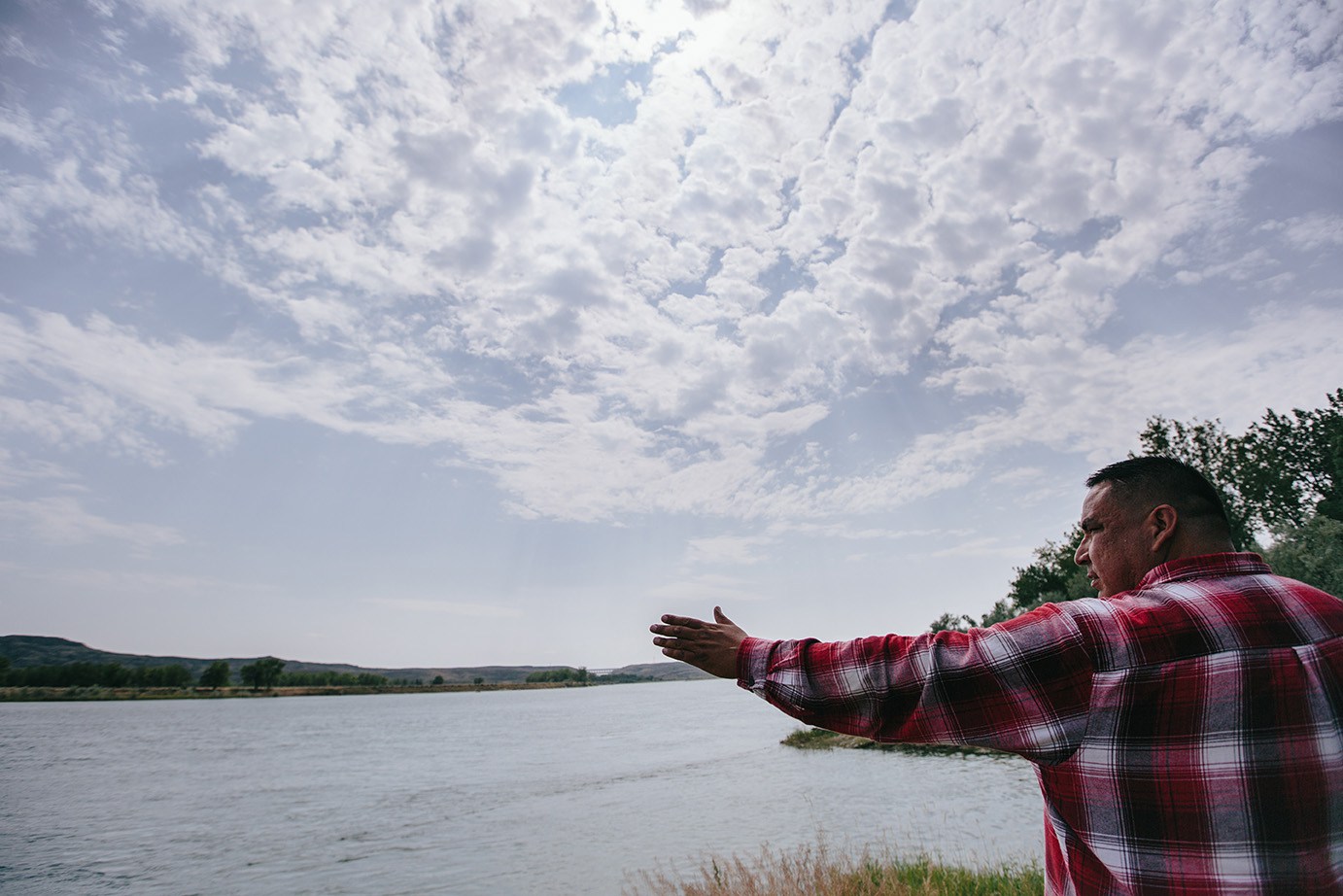
Lance Four Star points out the path of the Keystone XL oil pipeline near where it will cross 53 feet below the bed of the Missouri River. Just left of Four Star’s hand in the distance is the spillway of the Fort Peck Dam, the emergency release point for the fifth largest reservoir in the United States. Pipeline opponents fear a major spillway release could damage the pipeline, causing a leak that would contaminate their drinking water. Photo by Erika Peterman for Montana Free Press
TransCanada has promised the pipeline will bring jobs for locals, but Four Star doesn’t believe the company.
Standing on the riverbank where the Keystone XL pipeline is due to cross beneath the Missouri, Four Star examines photos of recently released TransCanada maps shared by a member of the tribal executive board.
This isn’t the first oil pipeline crossing site Four Star has been to, or opposed. He traveled in 2016 to the Standing Rock demonstration against the Dakota Access Pipeline as part of a veterans contingent.
That was the second time Four Star was gassed by the government, he says. The first time was in Army chemical warfare training.
Four Star says he took an oath when he enlisted in the Army to defend the United States against all enemies, foreign and domestic, and that Keystone XL fits the bill.
Keystone XL doesn’t threaten just living members of the tribes, but also burial grounds to the west of the reservation, as well as teepee rings and other sacred archeological sites, he says.
For Four Star, it’s the equivalent of building a pipeline through the Vatican.
“We’re not in the way of the pipeline. The pipeline is in the way of us,” he says.
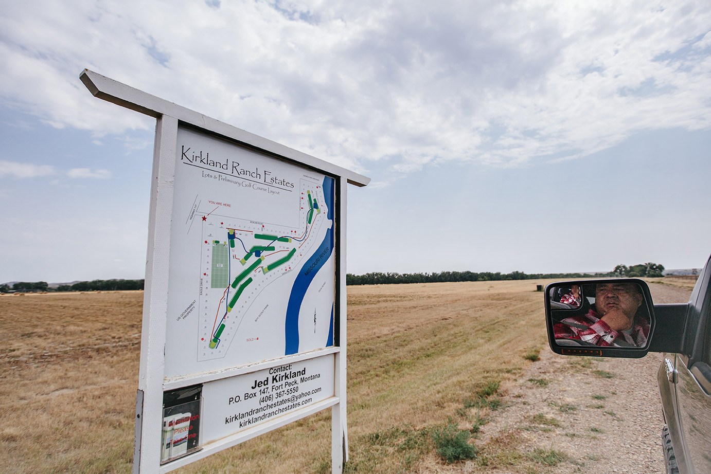
Six miles up the Missouri from the Milk River confluence is Kirkland Ranch Estates, a planned housing development of 91 residential and three commercial plots and a golf course. All that’s been built so far are roads. Four Star says it’s rumored the houses won’t go in, and instead the land will be the site of a man camp to house the workers who will build Keystone XL.
Jed Kirkland, the property’s developer, says that’s not true.
Kirkland says the man camp will be located a little more than a mile north on 117, on the northern side of its intersection with Mdu Road, which he knows because he helped TransCanada install the water line to that property. Kirkland says he doesn’t know whether the man camp will be good or bad for Kirkland Ranch Estates.
Kirkland Ranch Estates, an unbuilt housing development in Nashua near the pipeline crossing, is rumored to be the site of a future man camp for pipeline workers. Property developer Jed Kirkland says that’s not true, and that the man camp is going in a mile north. Photo by Erika Peterman for Montana Free Press
Four Star says meth didn’t get really bad on the reservation until 2008, when skyrocketing oil prices spurred a fracking boom in the Bakken Formation on Fort Peck’s eastern border that saw tens of thousands of workers, mostly single men, housed in hastily constructed trailer towns. Fueled by long hours, high wages, and nothing but prairie in every direction, man camps became centers of drugs and sexual violence, which have affected Native women in disproportionately high numbers.
“TransCanada says the workers coming in are of a different breed,” Four Star says. “Drug-tested, and with families.”
He doesn’t believe them.
“They also say the tar sands float,” he says, repeating a common joke among Keystone XL opponents.
Four Star is suspicious of any promises of safety from oil companies after the Kalamazoo pipeline spill.
While the oil traveling from the Bakken is a light, sweet crude easily pumped from wells and through pipelines, the tar sands-derived crude of northern Alberta that Keystone XL would carry is viscous.
Before tar sands crude can be pumped through a pipeline, it first has to be clawed out of cliff walls with bucket excavators, then heated to extract the heavy, viscous oil known as bitumen.
Bitumen is too thick to be pumped through a pipeline, so it has to be mixed with other hydrocarbons to thin it out, producing diluted bitumen.
TransCanada says that if Keystone XL ruptured, escaping diluted bitumen would simply float away on the Missouri, bypassing the underwater intakes of the tribes’ water system.
The plaintiffs suing the feds over Keystone XL’s environmental impact statement allege that the company’s claim is based on an oil spill model tailored to conventional crude oil, not tar sands crude. In comments on a draft EIS in 2013, TransCanada briefly contradicts its public stance that diluted bitumen floats.
“If oil does remain on the water surface for a sufficient time, without being cleaned up, there is the potential for some oil to sink,” TransCanada wrote.
Unlike in laboratory settings, when diluted bitumen spilled in Kalamazoo, its components separated, and the bitumen sank to the riverbed.
That’s why Four Star is worried when TransCanada says the man camps aren’t a threat to the reservation.
THE ACTIVISTS
According to a confidential email from Montana Fish, Wildlife and Parks chief of law enforcement David Loewen to FWP wardens and leadership, Nashua won’t be the only man camp.
Loewen says man camps are also expected to appear in the towns of Circle, 50 miles south of the Missouri, 50 miles up the Milk River in Hinsdale, and more than 100 miles to the southeast in Baker, where an oil on-ramp will be built for Bakken oil. TransCanada says the Hinsdale camp alone is expected to house 800 workers.
“Although man-camps bring a certain degree of law enforcement challenges, the primary enforcement focus is protest activity,” Loewen said in the email.
The email was released to the Montana ACLU as part of a campaign of statewide public disclosure requests the organization hopes will map police surveillance of Native Americans and environmentalists ahead of an anticipated Standing Rock-style protest against the pipeline
Angeline Cheek is a Fort Peck tribal member who went to Standing Rock in the fall of 2016, and an activist with Indian People’s Action, a Montana-based indigenous-rights group that has previously organized blockades against convoys hauling tar sands equipment through the state to Alberta.
Anti-pipeline activist Angeline Cheek says Keystone XL doesn’t just threaten the tribes’ drinking water, but tribal members as well, due to the lawlessness man camps planned nearby would bring to the reservation. Cheek says prayer marches across the reservation have been met with threats from armed ranchers and farmers from nearby white communities. Photo by Erika Peterman for Montana Free Press
Cheek says drugs and sexual violence have been a problem on the reservation for a long time, but that she doesn’t remember things being nearly this bad growing up. She says a couple of her cousins are addicted to meth, which she says flows onto the reservation from the Bakken oil field man camps, alongside sexually transmitted diseases and human trafficking.
For more than a year, anti-pipeline activists have marched from one end of the reservation to the other to raise awareness of the threat Keystone XL poses to the water network from which most of the surrounding off-reservation communities also get their drinking water.
Last April, a 60-mile march was held on Montana Highway 13 from the Canadian border north of the reservation south to the Missouri River. The first community the marchers passed through is the predominantly white town of Scobey, which sits in the middle of a 25-mile strip of farm and ranch land between Canada and the Fort Peck Reservation.
Even with ACLU observers present, by all accounts the atmosphere was tense. Cheek says that just south of the Canadian border marchers encountered gun-holding farmers who followed the marchers to Scobey in their cars. Cheek says she and another marcher lagged behind in town, handing out flyers, and were surrounded by locals shouting threats.
“‘Go Trump! Let the pipeline through! Let’s scalp and kill these Indians!’” Cheek says they yelled. “That really scared me.”
She and the other marchers jumped into one of the march’s support vehicles and caught up with the other activists south of town. As the march continued, Cheek and Four Star say, they were shadowed and circled by truck-driving locals who heckled the marchers whenever they stopped for prayers at water crossings. Cheek says the hecklers followed the march nine miles onto the reservation before turning back. Cheek says she saw full gun racks on the trucks’ rear windows.
ACLU Legal Director Alex Rate confirmed the aggressive comments, but could not confirm the presence of guns.
“The reservation is a concentration camp, and now we’re going to be surrounded by man camps. It’s like being surrounded by the KKK,” Cheek says.
Cheek says the tribal government hasn’t prepared for the violence that pipeline construction could bring to the reservation if the pipeline isn’t stopped by the lawsuit in Great Falls.
THE TRIBES
Although the Fort Peck executive board passed a resolution in 2015 opposing Keystone XL, the tribes are not party to the lawsuit opposing the pipeline. Instead, for the past year they have attempted to negotiate with TransCanada to reroute the pipeline.
Protesters have scared off TransCanada representatives from public meetings with the executive board, which has led to closed meetings, giving ammunition to activists who accuse the tribal government of collaborating with the pipeline company.
According to public notices that TransCanada published in eastern Montana newspapers in 2008, two other routes were proposed downstream of Fort Peck’s water intake. One would have crossed the reservation, with the other cutting east above the reservation’s northern border before turning south, “avoiding BIA lands,” as a 2009 TransCanada document stated. TransCanada finally chose the shortest route, the pipeline’s current path, which crosses the Missouri below the Fort Peck Dam spillway and upriver of the water intake.
Members of the Tribal Executive Board of the Fort Peck Assiniboine and Sioux Tribes meet on Thursday, Aug. 2 in the council chambers of the administration building in Poplar, Montana. Tribal Chairman Floyd Azure said he plans to ask the board to take legal action against the federal government over the threat the Keystone XL pipeline’s Missouri River crossing poses to Fort Peck’s $300 million drinking water network. Photo by Erika Peterman for Montana Free Press
It is unlikely that TransCanada could easily change the route even if the company wanted to. When the Nebraska Public Service Commission (PSC) denied TransCanada’s preferred pipeline route through the state’s western Sand Hills last December, plaintiffs latched on to the fact that the alternative route the Nebraska PSC approved hadn’t been studied in the EIS approved by the feds.
On July 30, the State Department released a draft environmental assessment of the current Nebraska route that forecasts a negligible environmental impact.
On Aug. 15, Judge Brian Morris ruled that the draft assessment wasn’t enough, and that the State Department must file a supplement to the EIS that considers the new Nebraska portion of the route, which the 2014 EIS did not cover. Morris has yet to rule on the wider aspects of the case.
Referenced in the Nebraska draft assessment was an unattached TransCanada risk assessment of the pipeline’s Missouri River crossing site near Fort Peck that the company submitted to the U.S. Army Corps of Engineers, the agency in charge of granting river-crossing permits.
While publication of the federal government’s Nebraska assessment was announced in the Federal Register and posted to the State Department’s Keystone XL website, TransCanada’s Missouri River risk assessment was published exclusively on the pipeline company’s website sometime in July with no announcement.
It’s a document the Fort Peck tribes have been searching for.
“I don’t think this is worth the paper it’s written on,” Fort Peck executive board Chairman Floyd Azure says, throwing the 111-page risk assessment down on his desk in the sprawling tribal government complex on the outskirts of Poplar.
The risk assessment is dated July 31, 2017. Azure says the tribes have been asking TransCanada to see it for more than a year. Azure says the company refused to provide the document, saying that doing so would violate federal law.
TransCanada did not respond to multiple requests for an interview regarding Keystone XL.
Azure says the tribes finally received a copy on July 27 this year — nearly a year after the assessment was written — from Gov. Steve Bullock’s office. Ronja Abel, a spokeswoman for Bullock’s office, told MTFP in an email that she downloaded the document from TransCanada’s Keystone XL website after it was recently posted. The plaintiffs suing to stop the pipeline didn’t have a copy until Aug. 7, when MTFP sent it to them.
Azure is furious, because despite years of public comment, court testimony, letters to state and federal governments, protests, news reporting, and even a personal letter to Canadian Prime Minister Justin Trudeau, the risk assessment makes no mention of Fort Peck’s water network, the reservation, or the tribes.
“I’ve just got no confidence in them at this point,” Azure says. “We’re basically an afterthought.”
The Keystone XL oil pipeline is planned to cross the Missouri River just upstream of the confluence with the Milk River, which Meriwether Lewis named from this overlook for its “peculiar whiteness.” The Milk and the Missouri serve as the borders of the Fort Peck Indian Reservation. Photo by Erika Peterman for Montana Free Press
The Fort Peck tribes have treaty rights to the waters of the Missouri River, the center of which constitutes the reservation’s southern border. Azure says the tribes should have been consulted for the risk assessment, considering that they’re the ones at risk, and that the state and the Bureau of Indian Affairs should have told TransCanada to talk with the tribal government.
“If there’s a spill, it’s going to be on our land and in our water,” Azure says, motioning to his coffee mug. “And it don’t float.”
Azure says that if the pipeline is built, there will be Standing Rock-style protests in northeast Montana. He says he doesn’t want to see that, but because the pipeline doesn’t touch tribal land, he’s powerless to stop construction, making protest inevitable. He says the only way to stop a mass protest is a legal injunction on pipeline construction, as the plaintiffs in the federal lawsuit upriver in Great Falls are seeking.
“I’m pushing for a lawsuit. I want it, and I want those guys [the tribal executive board] to go along with it,” he says.
Azure says that even without disruptive anti-pipeline “troublemakers” present at meetings with TransCanada, it quickly became apparent there would be no concessions, such as routing the pipeline downriver of the water network intake.
“It wasn’t a negotiation. They just told us what they were going to do,” he says.
Finally getting the risk assessment last month and seeing that it didn’t mention the risk to the tribes was the last straw for Azure. He says he plans to ask the executive board to vote on joining the federal lawsuit to stop the pipeline, though it’s unclear whether that’s possible, considering that oral arguments have been made and the parties are awaiting Morris’ ruling. Azure says he also wants to sue TransCanada for negligence.
THE PIPELINE
Fort Peck Dam operations manager Darin McMurry watches two fishermen in a walleye boat in a bay carved into the Bearpaw Shale at the bottom of the dam’s mile-long spillway. Compared to the shale, which formed millions of years ago and crumbles like sand despite looking like rock, the bay is young. It formed in 2011 when a heavy snowpack in the Rockies melted and combined with record spring rains behind the dam.
To prevent a catastrophic domino collapse of the six Missouri River mainstem dams holding back the third-, fourth-, fifth- and eleventh-largest reservoirs in America, which could have cleaved the nation in two with cataclysmic flooding, the Army Corps of Engineers decision-makers who run the dams from their base in Omaha, Neb. opened the spillways.
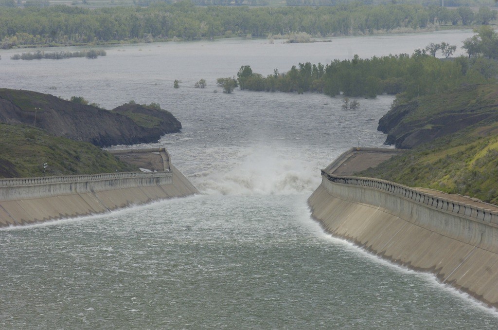
Record-high flooding and runoff in 2011 forced the Army Corps of Engineers to open the flood gates on the Fort Peck Dam spillway for only the fifth time in the dam’s history. Record flows of up to 52,000 cubic feet of water per second rushed through its 16 fully opened gates, causing more than $200 million in damage to the outflow. Photo by John S. Adams for Montana Free Press
The Fort Peck Dam spillway maxed out in 2011 at 52,000 cubic feet of water per second rushing through its 16 fully opened gates. McMurry says the floodwaters accelerated to 45 miles per hour rushing down the concrete spillway, crashed into the riverbed 225 feet below, and carved out the bay, nearly undermining the entire structure, which required tens of millions of dollars in repairs.
“I don’t want to have a year like that again,” McMurry says.
He doesn’t want to, but he probably will.
As of Aug. 1, the spillway was open and expelling a relative trickle of 5,000 cubic feet of water per second, which crashes into a new concrete extension on the sides and bottom of the spillway lip, preventing the bay from growing. It’s only the sixth time in the dam’s 78-year operating history that the spillway has been opened, the first being in 1975, which set the previous release record of 35,000 cfs. McMurry has seen half of those openings since he began working at the dam in the 1990s.
Montana Free Press: Darin McMurry discusses the Fort Peck Dam spillway. Video by Colin Ruggiero
In addition to carving the bay at the bottom of the spillway, the 2011 floodwaters scoured the riverbed downstream, though McMurry says the Corps doesn’t know the full extent. A recently released TransCanada analysis of the spillway’s scouring threat to the pipeline states that even if the spillway released at its maximum output of 350,000 cfs, the flow would scour only 21.7 feet down into the riverbed, with the pipeline still safe at 53 feet below the riverbed.
In the case of such flooding, the analysis says, “the devastation will be immense on or near the floodplain for the entire length of the river. However, design of pipeline valves would withstand the potential inundation and flows of such a massive flood event.”
Pipeline opponents have yet to weigh in on TransCanada’s conclusions, but are skeptical of studies paid for by oil companies that determine oil projects to be safe, such as lab results showing that tar sands bitumen floats. McMurry says the spillway’s maximum output is 230,000 cfs, and cannot speak to where TransCanada got the 350,000 figure.
There’s precedent in Montana for river scouring breaking oil pipelines, which TransCanada says is why the company plans to bury Keystone XL so deep. River scouring from the 2011 flood broke an oil pipeline buried only a few feet beneath the Yellowstone River (which Keystone XL must also cross), spilling 63,000 gallons of crude.
Like the Missouri River crossing risk assessment, the scouring analysis doesn’t mention the tribes, the reservation, or the threat a pipeline spill poses to the drinking water network.
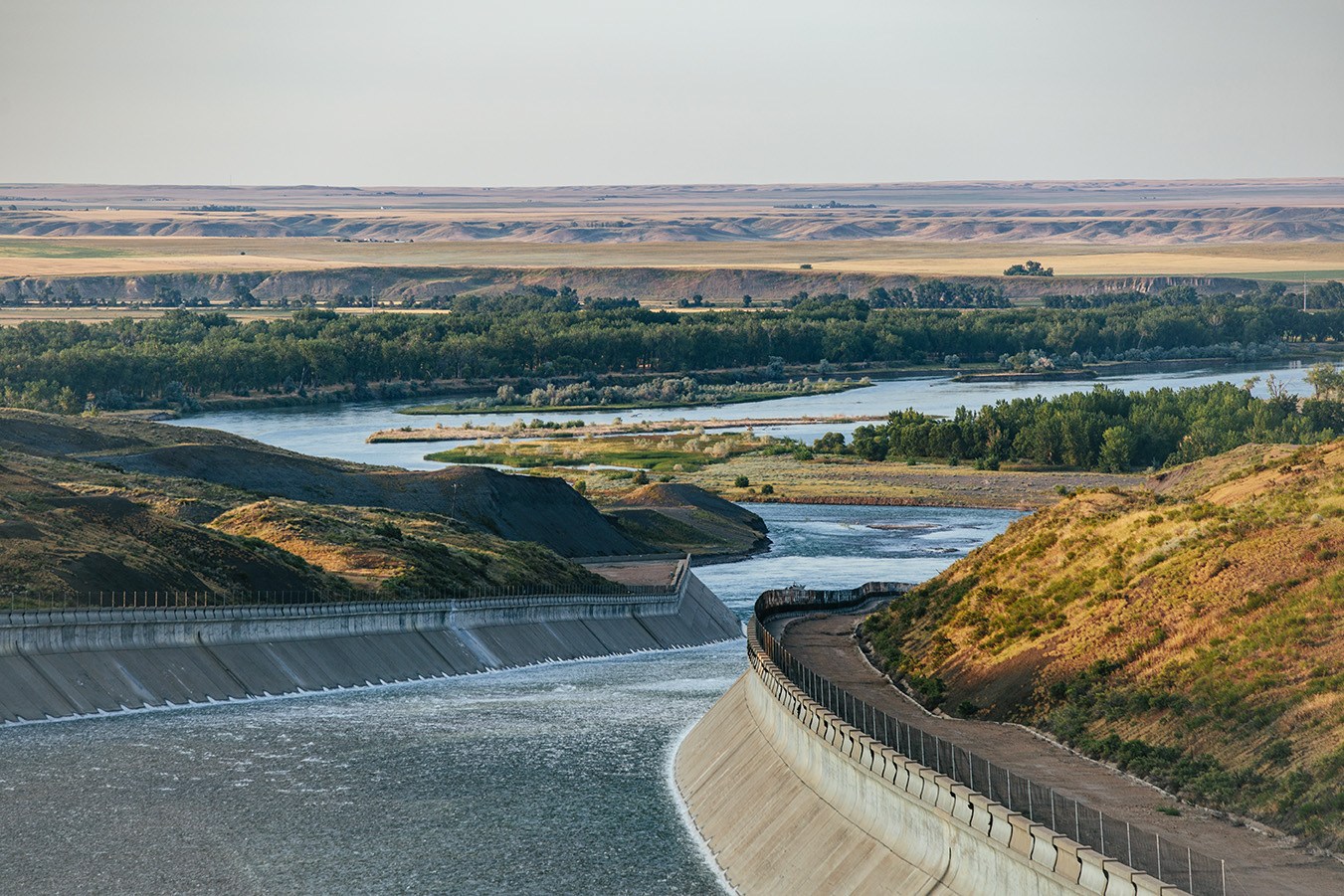
The proposed site where the Keystone XL pipeline would cross beneath the Missouri River is less than two miles downstream of the outflow of the Fort Peck Dam spillway. Photo by Erika Peterman for Montana Free Press
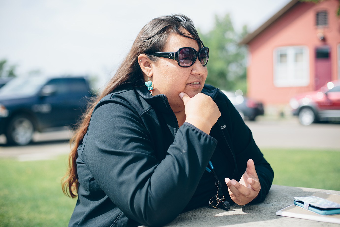
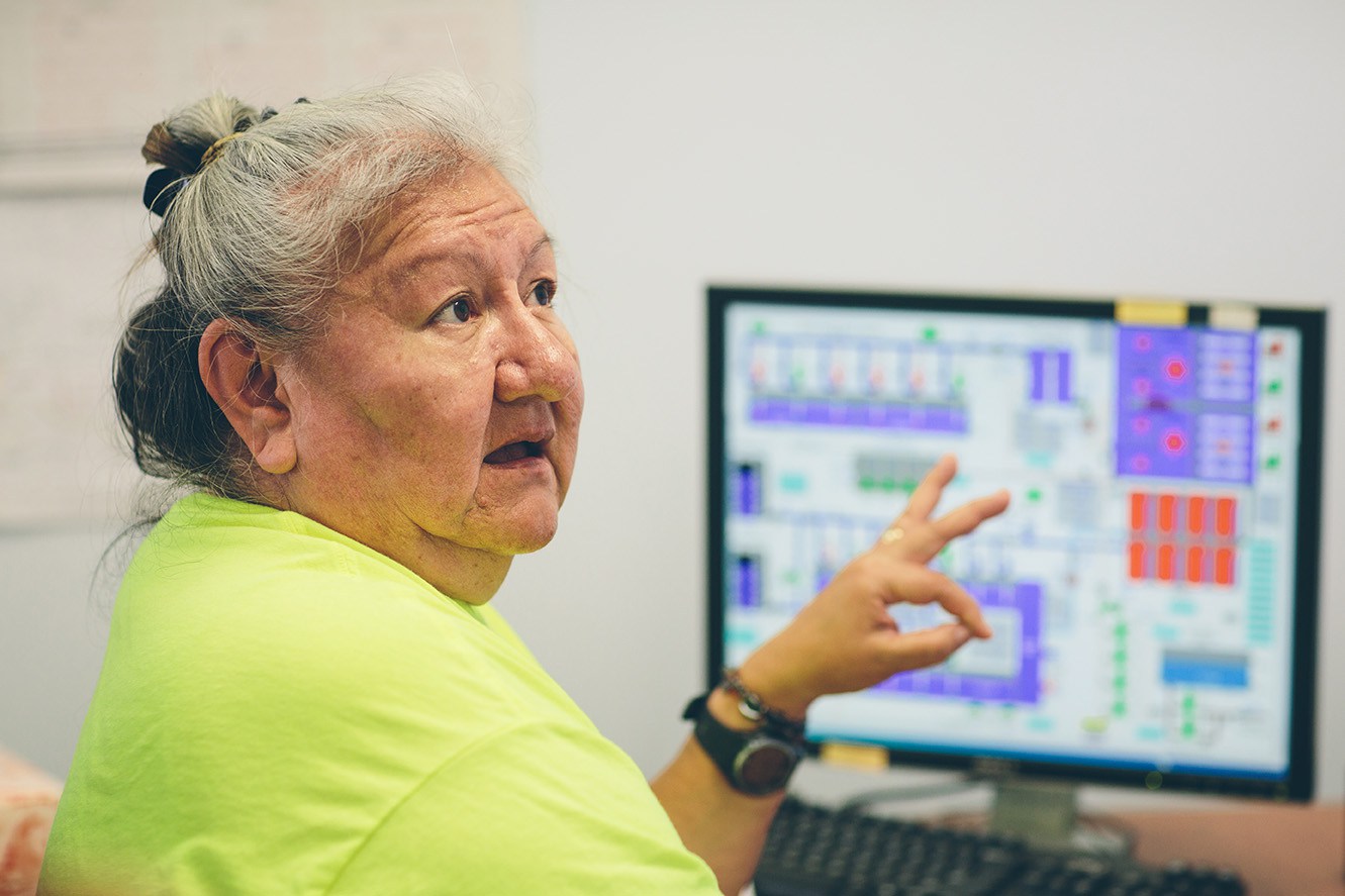
“If that spill ever happens, they say we’ve got a day or two before it hits us,” says Sandra White Eagle, program director of the Assiniboine & Sioux Rural Water Supply System.
“But we figure we’ve got a couple hours,” she says.
White Eagle says it takes 7 to 12 minutes for water to travel from the intake on the Missouri to the water treatment plant at the intersection of U.S. Route 2 and Montana Highway 13 between Wolf Point and Poplar.
White Eagle says she’s always wanted to run her own water treatment plant, having completed a wastewater treatment program at Montana State University-Northern and worked at plants in Great Falls and Chinook. When she applied for a similar job at Wolf Point, she says, the bosses said she was qualified, “but we’re really looking for a male.”
White Eagle, who worked 20 years for the Fort Peck office of Environmental Protection, says she worked to get the reservation up to EPA water-quality standards. She ran a boat collecting river samples beneath cottonwood trees old enough to have been seen by Lewis and Clark when they camped just downriver from Keystone XL’s proposed crossing site. She was promoted earlier this year to run the water network.
The $300 million water network was mandated by Congress in 2000 after decades of oil production north of Poplar left the local aquifer contaminated with carcinogenic compounds and saltier than the sea. The families that drew their water from the area drank bottled water for years until a water line was routed north from Poplar. The tribal seat was hooked into the water network only about a year before a toxic plume reached the town’s groundwater.
Sandra White Eagle is a Fort Peck tribal member and program director of the Assiniboine & Sioux Rural Water Supply System, which provides drinking water to communities off and on the reservation. She says a leak from the Keystone XL pipeline 77 miles upriver of the water treatment plant’s Missouri River intake would cut off the tribes’ drinking water. Photo by Erika Peterman for Montana Free Press
At the Fort Peck water treatment plant, Missouri River water goes through a multi-step process including chemical treatment, coagulation, flocculation, maturation, sedimentation, clarification, and disinfection. On average, the plant pumps out 3,000 gallons of clean drinking water per minute, but on days when the temperature is over 100 degrees, White Eagle stays as late as 8 p.m. monitoring water use as it rises in order to keep output steady. Her husband brings her supper.
“When [the pipeline] breaks, we’re dead in the water,” White Eagle says.
If a pipeline spill shut down the water network, White Eagle says, the communities on and around the Fort Peck Reservation that rely on it would be without water until they could reconnect to whichever old groundwater systems aren’t polluted by the toxic plume. She says Poplar could draw from a backup well far to the west of town, but that’s their last reserve of clean water.
White Eagle says 60 to 80 percent of the water the plant produces goes to the Dry Prairie Rural Water Supply System, an off-reservation partner network that provides water for many of the nearby white communities.
Montana Free Press: Sandra White Eagle on Keystone XL threats to tribal water system. Video by Colin Ruggiero
Nashua began receiving water from the plant in March, and negotiations are underway to extend the network to Scobey, where, White Eagle says, you can smell hydrogen sulfide — a foul-smelling gas — when you flush the toilet. When the network is complete, it will serve 30,000 people in northeast Montana.
THE GOVERNMENT
In December 2012, Montana’s outgoing Democratic governor, Brian Schweitzer, chaired his final meeting of the Montana Land Board, a panel of the state’s top five elected executive officials. The all-Democrat board was voting on selling easements to TransCanada for Keystone XL to cross Montana’s rivers, but first had to face public comment. The four other officials on the board were Montana’s then-Attorney General Steve Bullock (now the governor), Secretary of State Linda McCulloch, State Auditor Monica Lindeen, and Superintendent of Public Instruction Denise Juneau, the first Indian woman in the country to be elected to a statewide executive position.
Critics, including the Montana Environmental Information Center and Northern Plains Resource Council, said it was irresponsible for the board to consider selling the easements before TransCanada had done safety assessments, and premature considering that federal approval for the project hadn’t yet been granted.
When the environmentalists said the board had a responsibility to review the environmental threats posed by Keystone XL, particularly the crossing downstream of the dam spillway, Schweitzer replied that the board merely handled the money, and that the Montana Department of Environmental Quality was responsible for environmental concerns. MDEQ had already approved Keystone XL nine months earlier.
MDEQ Director Tom Livers said last year that the threat posed by Keystone XL to the water network was “not identified as an issue during scoping, in public comments or in the tribal consultation process.”
The Land Board voted 5-0 to approve the sale of easements to TransCanada for $741,000 without discussion of the Fort Peck tribes’ drinking water.
It’s not clear why TransCanada’s recently published Missouri River safety assessments don’t mention the Fort Peck tribes’ drinking water. According to the EIS, TransCanada has known for years that the pipeline poses a threat to the reservation. The tribes have sent multiple letters to successive U.S. secretaries of state, and the State Department admitted knowledge of the water intake and network years ago in the pipeline’s environmental impact statement, though its knowledge was incomplete.
The “affected environment” section of the environmental impact statement, published in 2014, notes that the Assiniboine & Sioux Rural Water Supply System is 77 river miles downstream of the proposed Missouri River crossing, “and replaces previous groundwater supplies that are no longer in use,” omitting the fact that much of that groundwater was contaminated by oil extraction, necessitating construction of the Assiniboine Sioux Rural Water Supply System (ASRWSS).
The section of the Missouri River where the Keystone XL pipeline is planned to cross teems with life. Part of the lawsuit seeking to prevent construction claims the government did not adequately address threats to local endangered species like Whooping Cranes and Pallid Sturgeon. Photo by Erika Peterman for Montana Free Press
In the statement’s public comment section, the State Department addressed how “potential impacts to tribal surface water systems [are] assessed,” mentioning both the ASRWSS and the Mni Wiconi Rural Water Supply System downriver on the Pine Ridge Indian Reservation in South Dakota.
“The possibility of a spill reaching the intakes for tribal water systems are exceptionally remote due to the presence of upstream barriers such as dams, as well as the downstream distance between proposed project waterbody crossings and these intakes,” the statement reads. While there are multiple dams between Pine Ridge and the proposed pipeline crossing in Montana, there are none between Fort Peck’s water intake and the site, and the environmental impact statement doesn’t mention any other type of barrier.
According to the environmental impact statement’s “environmental consequences” section, spill impacts to the water networks and their intakes could include “the temporary loss of supply during spill response and cleanup.”
The document also states the possibility of a spill reaching the tribal water networks is remote, but the explanation given is that “a distance of at least 10 miles downstream from the proposed pipeline was recommended for the identification of sensitive resources that could be affected by a release from the proposed pipeline,” and that the tribal water networks are “significantly beyond the proposed Project impact assessment buffer.”
Simply put, the tribes’ water supplies are outside of the environmental impact statement’s 10-mile line, and therefore were not considered threatened, despite the fact that the EIS states in the same paragraph that a pipeline spill could shut them down.
Eastern Montana is no stranger to pipelines spilling oil into sources of drinking water.
Another shallow Yellowstone River oil pipeline was cracked open by an ice jam in January 2015, spilling an estimated 30,000 gallons of crude into the river and contaminating the drinking water of some 5,000 people in the downriver town of Glendive.
The month after the Glendive spill, the Fort Peck executive board unanimously passed a resolution opposing construction of the Keystone XL pipeline because of the threat it posed to the water network.
When President Barack Obama directed the State Department to reject Keystone XL later that year, the reason given wasn’t the threat of spills, but rather that the United States had to take the lead on combating global warming four weeks ahead of the Paris climate change conference.
When President Donald Trump resurrected the pipeline in 2017, within days of taking office, his decision was based on the same environmental impact statement available to the previous administration. It took environmental and indigenous-rights groups only a couple of months to put together a lawsuit challenging what they described as Trump’s “rubber-stamping” of the pipeline. That lawsuit was filed in federal court in Montana, the state where the Canadian pipeline enters the United States. Plaintiffs include local environmental groups that warned the Montana Land Board in 2012 about the dam spillway threat and a victim of the 2015 Yellowstone River oil spill.
While the Fort Peck executive board did not join the lawsuit, Bill Whitehead, chairman of the water board that runs the water network, is a named plaintiff, though not in his official capacity.
The lawsuit argues that the Trump administration came to a completely opposite conclusion using the same data as the Obama administration (data it says was already biased in favor of the pipeline), ignoring fatal flaws in the environmental assessment, such as the threat posed to the Fort Peck reservation’s water, pallid sturgeon, and endangered whooping crane migratory paths, as well as the pipeline’s contribution to climate change.
Both parties expect that District Judge Brian Morris will issue a full ruling on the lawsuit by the end of the year.
If Morris rules in favor of the plaintiffs and blocks the pipeline, most observers expect the Trump administration to appeal the decision to the 9th Circuit Court of Appeals. If Morris’s decision survives an appeal there, the case would likely end up in the U.S. Supreme Court, where, as TransCanada’s lead attorney Peter Steenland has pointed out, environmental lawsuits go to die.
Hunter Pauli is a Seattle-born, Missoula-based freelance investigative reporter and graduate of the University of Montana School of Journalism. You can follow him on Twitter @paulimeth.
This story originally appeared on Montana Free Press on August 21, 2018. It is published under a Creative Commons license.